Beyond the famous wildlife crater, the Ngorongoro Highlands hold volcanic peaks, grasslands and lakes. Walks, pastoralist landscapes and archaeological places reveal different parts of the region's natural and human history.
A landscape built by volcanoes
The highlands lie along the eastern edge of the Great Rift Valley. Volcanic activity shaped the dramatic crater walls, peaks and basins that now divide forests, grasslands and lakes.
Ngorongoro Crater is a caldera, formed when a volcano collapsed. The surrounding area includes other crater landscapes and mountain summits, each with a different physical character.
Elevation makes a difference. Conditions on a misty crater rim or an exposed highland trail can be cool and wet even while the plains below are warm.
Ngorongoro Crater
The descent into the crater reveals grasslands, wetlands and other habitats within its steep walls. Wildlife may include buffalo, zebra, wildebeest, elephants, lions and many bird species. The combination of geological scale and living ecosystems distinguishes the crater from an ordinary open-plains game drive.
The wider Ngorongoro Conservation Area is not simply the crater. It encompasses highlands, savannah, archaeological places and a pastoralist cultural landscape.
Conservation-area entry or transit and a crater descent have distinct rules and charges.
Empakaai
Empakaai offers a different volcanic setting. Instead of descending by vehicle into a busy wildlife-viewing area, the experience centres on a highland crater with a lake and surrounding slopes.
A guided walk can reveal the vegetation and views of the highlands from another perspective. The physical effort and terrain are not the same as a crater-floor game drive.
For someone who already knows Ngorongoro Crater, Empakaai can illuminate the region's volcanic diversity without repeating the same wildlife encounter.
Olmoti
Olmoti is another volcanic landform in the highlands. Its appeal is associated with walking, crater geography and the surrounding upland scenery.
A walk focuses attention on terrain, plants and views rather than vehicle-based wildlife watching.
Together, Ngorongoro, Empakaai and Olmoti show why the word crater does not describe just one kind of experience.
Ol Doinyo Lengai
To the north-east, Ol Doinyo Lengai rises above the rift landscape. Its name is commonly translated from Maa as the 'Mountain of God'. The volcano is geologically remarkable for the natrocarbonatite lava associated with its eruptions, unlike the more familiar silicate lavas of many volcanoes.
A mountain ascent here is unlike a crater wildlife drive or a gentle viewpoint walk. Loose terrain, steep slopes, altitude, exposure and volcanic conditions can make it demanding and hazardous. The mountain's activity and current access conditions matter more than old descriptions of a successful ascent.
Lengai is worth studying for its geology even without an ascent.
Mount Loolmalassin
Mount Loolmalassin is among Tanzania's highest mountains and part of the Ngorongoro highland landscape. Compared with Kilimanjaro's established trekking routes, it is less familiar to most visitors.
Its interest lies in the high plateau, upland environment and views across the surrounding volcanic country. This is not a place to choose solely from a summit ranking. A meaningful visit depends on which terrain can be accessed, with what support and under whose authority.
Lake Eyasi
Lake Eyasi belongs to the wider Rift Valley landscape rather than to Ngorongoro's crater system. The seasonal lake basin, surrounding dry-country environments and communities offer a very different perspective from the green crater rim.
Visitors sometimes encounter the region through cultural-tourism descriptions of particular communities. These accounts should reflect contemporary people and livelihoods, not portray residents as living exhibits of a supposedly unchanged past.
The landscape, local economies and histories are substantial subjects in their own right.
Olduvai, Laetoli and Mumba Cave
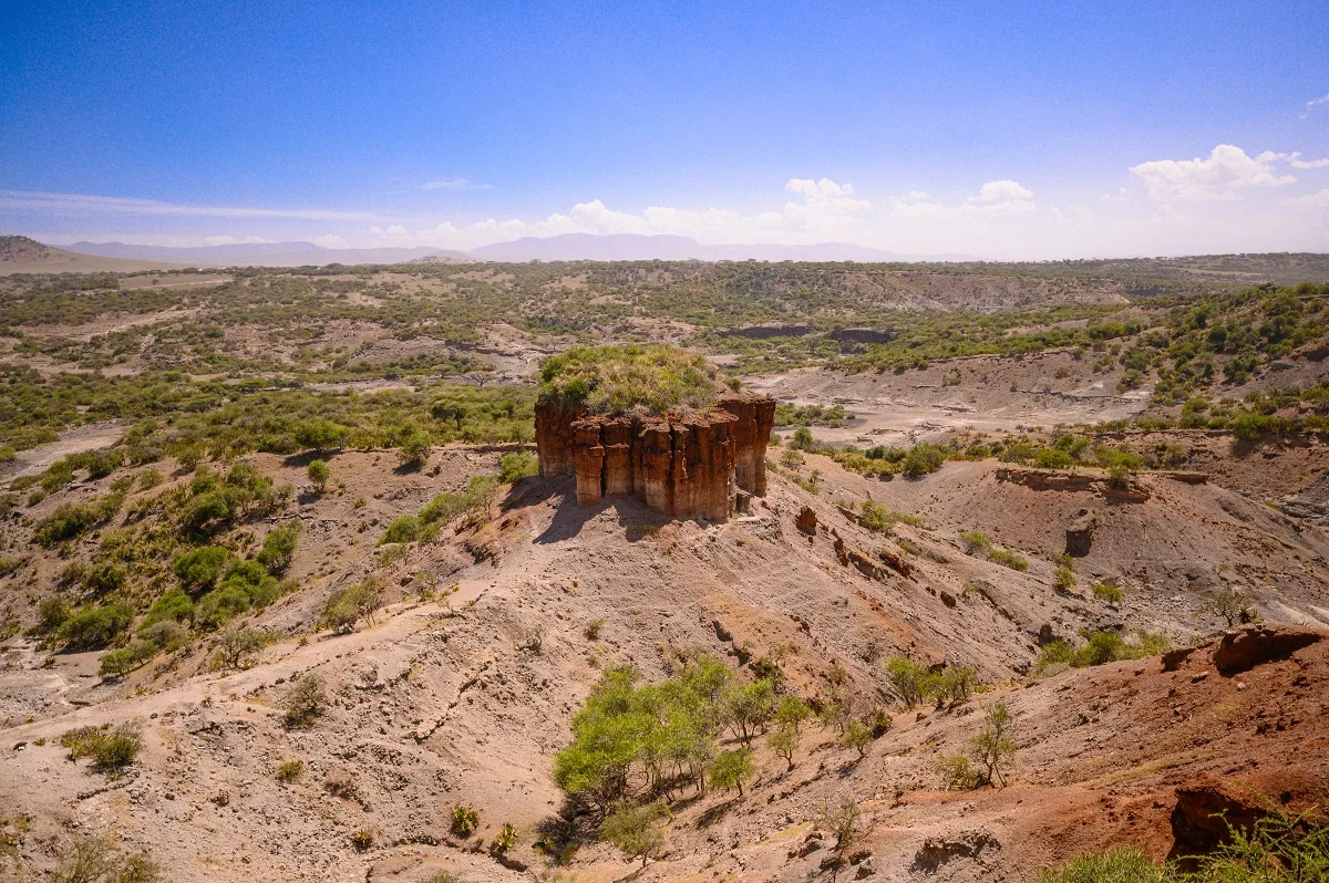
Some of Tanzania's most important archaeological landscapes lie within or near this wider region.
Olduvai Gorge has contributed greatly to the study of early humans, tools and ancient environments. A museum encounter is particularly valuable when it explains how evidence is interpreted rather than reducing discoveries to a list of fossils.
Laetoli is associated with ancient hominin footprints that provide evidence of early bipedal movement. Conservation of such evidence imposes access limits: learning about a discovery does not require standing on the original site.
Mumba Cave, near Lake Eyasi, is another important archaeological subject. It belongs to a different setting and research history from Olduvai, showing how much of the region's human past extends beyond a single gorge.
Explore Tanzania's archaeology and heritage.
Communities and conservation
The highlands have long been associated with pastoralist communities and livestock alongside wildlife. Ngorongoro is therefore a place where questions of conservation, livelihoods, land use and cultural heritage meet.
That history should not be reduced to a generic 'Maasai village experience'. Community participation requires consent and accurate local interpretation. Current conservation and land-use policies also deserve attention when discussing the region.
Learn about conservation and communities.
Compare highland experiences
| Interest | Place | What distinguishes it |
|---|---|---|
| Wildlife in a dramatic geological setting | Ngorongoro Crater | Caldera landscape and wildlife viewing |
| A highland crater walk | Empakaai | Lake and crater slopes |
| Upland walking and volcanic scenery | Olmoti | A different crater environment |
| Active-volcano geology | Ol Doinyo Lengai | Exceptional volcanism and demanding terrain |
| High mountain landscape | Loolmalassin | Upland scenery beyond the usual climbing circuits |
| Rift Valley lake and communities | Lake Eyasi | Seasonal basin and local life |
| Archaeology and human evolution | Olduvai, Laetoli, Mumba Cave | Different records of early people and environments |
The table is a guide to interests, not an itinerary. Each place has its own access arrangements and physical demands.
Conditions and official charges
The highlands can be cool, windy or wet; crater drives and mountain walks respond differently to weather. Consider the type of activity, not only the month.
Browse fees to inspect represented conservation-area and activity charges; Calculate fees for your circumstances; and Trip scheduling for supported protected-area visits. These tools do not arrange volcano climbs or independent transport into the highlands.